When considering the environment geographers tend to distinguish between two aspects, the:
- biophysical environment, consisting of those elements that are naturally part of the physical environment (lithosphere, hydrosphere, atmosphere) plus the living things that occupy and interact with that environment (biosphere); and,
- built environment, also referred to as the human or the cultural environment.
Biophysical environments achieve a natural equilibrium. This is a sustainable, dynamic equilibrium. Once humans and their cultural processes are introduced, the equilibrium point inevitably shifts. Geographers describe the way humans act on the environment as management. In the absence of humans environmental change is unimpeded, once humans are introduced change has an additional cultural dimension. Now unimpeded natural change is interrupted by human activity.
Under these conditions a new equilibrium point develops, but just where it is, and how sustainable the new equilibrium might be, will depend on the nature of human activity. If the activity is purely extractive or exploitative, this can result in significant disruptions to the lithosphere, hydrosphere and atmosphere. Under these conditions the biodiversity of the environment will be reduced. In such circumstances there maybe large amounts of land, water and atmospheric pollution as well as great damage to the biosphere. In acute conditions this can also greatly disrupt the human environment and lead to significant physical, psychological and spiritual disturbances.
Disturbances in the environment can become quite significant global issues. Geographers are concerned about the implications of such human induced changes for ecological sustainability, governance, social justice and equity. During their Stage 4 geographical studies all students were expected complete course work in the general topic area of Global Issues and the Role of Citizenship. In covering this topic they were expected to learn to
- explain the links between human actions and the consequences for ecological sustainability on a global scale
- describe the spatial dimensions of the issue
- describe the ecological dimensions of the issue
- identify perspectives and bias about the issue, including in media reports
- describe the actions of individuals, groups and governments in relation to the issue
- communicate appropriately with organisations to participate as a global citizen
From Board of Studies, NSW. Geography Years 7 to 10 Syllabus. Page 33
Global Issues and the Role of Citizenship constituted the students’ prior learning for this topic Issues in the Australian Environment. Skills development was embedded in the global study with the processes of geographic inquiry along with the written and graphical organization of geographical information being important elements.
Developing the Research Questions
Asking the right questions is essential in acquiring geographic information, indeed most information. Students are expected to be able to ask geographical questions to support their acquisition of skills and understandings. The geography syllabus scaffolds this by providing a list of the key geographical questions.
From Board of Studies, NSW. Geography Years 7 to 10 Syllabus. Page 20
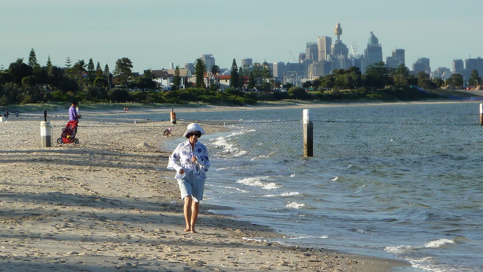
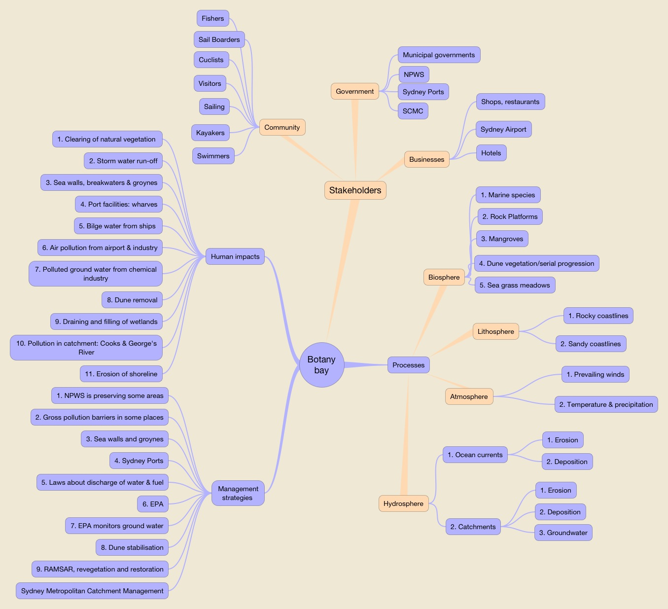
Applying these questions to Botany Bay is both challenging and highly relevant. The Bay, its catchment and coastal environment, is a complex area biophysically and culturally. There are many stakeholders whose levels of concern for human impacts on the biophysical environment are varied. All have ideas about the appropriate management of this coastal environment. Resolving conflicts inherent in the different views and agendas of stakeholders involves the consideration of management implications for the economy, the society and the environment.
In heavily industrialised coastal areas like Botany Bay the fundamental questions can be difficult for students to answer, so clear scaffolding was essential. This was the challenge of the field study.
Mapping the Field Study from the Syllabus
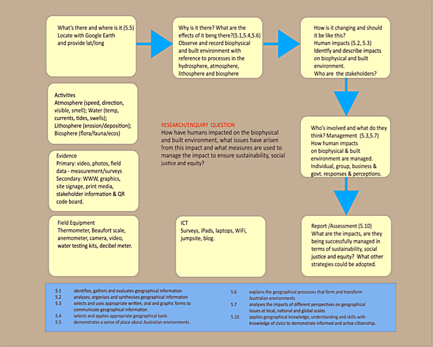
We quickly developed this chart as our first guide. Eight student outcomes expected in the virtual field study are listed at the bottom. These were taken directly from the syllabus outcomes that apply to this topic.
- 5.1 identifies, gathers and evaluates geographical information
- 5.2 analyses, organises and synthesises geographical information
- 5.3 selects and uses appropriate written, oral and graphic forms to communicate geographical information
- 5.4 selects and applies appropriate geographical tools
- 5.5 demonstrates a sense of place about Australian environments
- 5.6 explains the geographical processes that form and transform Australian environments
- 5.7 analyses the impacts of different perspectives on geographical issues at local, national and global scales
- 5.10 applies geographical knowledge, understanding and skills with knowledge of civics to demonstrate informed and active citizenship.
From Board of Studies, NSW. Geography Years 7 to 10 Syllabus. Page 40
From this point it was possible to pose research questions in the virtual field study that were consistent with the context, the key geographic questions and the outcomes required for students:
- How have humans had an impact on the biophysical and built environment?
- What issues have arisen from these impacts?
- What measures are used to manage the impacts in ways that ensure sustainability, social justice and equity?
Mapping the structure of the field study
With this basic work-up completed we brain stormed the structure of the field study. We used iThoughtsHD which runs on an iPad. There’s a useful overview of the app’s operation on YouTube. This one isn’t in English but it’s well constructed.
iThoughtsHD is a versatile program that can be exported in a variety of formats. So it’s very easy to email versions of your work to colleagues.
Using iThoughtsHD we mapped out a basic scaffold for the field study. I might add that this was only the second time I’d used the app.
Once this structure was completed it provided us with a clear set of secondary data gathering tasks. We then began searching and book-marking sites that provided useful secondary data.
Our biggest challenge was primary materials. There were several solutions:
- a series of six short videos supported by photographs shot in the field
- a survey of stakeholders built in SurveyMonkey which provided some genuine primary data.
- A collection of 30 original photographs in a virtual museum display. Each image was related to a QR code that allowed students to access short descriptions of the photo.
Shooting and editing the videos
The videos covered:
- Bare Island;
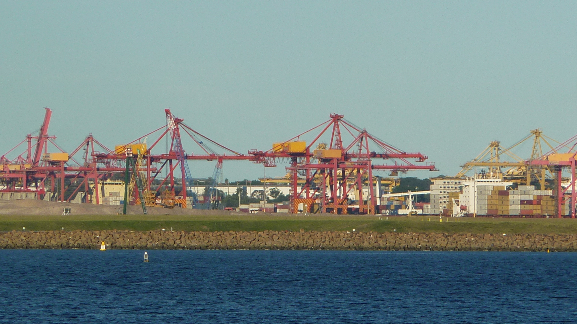
- Port Botany;
- Port Botany Extension;
- The Cooks River Mouth;
- Lady Robinsons Beach; and
- Towra Point.
Here is the first video on Bare Island, by way of example.
I prefer to work with iMovie, but could just as easily have used Adobe Premier. They were almost all shot, in a 16:9 HD format to a resolution of 1920×1080 pixels, with a Sanyo Xacti hand held digital video camera. Some of the shots did have to be balanced on a monopod. In editing it was possible to digitally remove some of the inevitable hand shake. While the results might not be commercial broadcast standard they are quite adequate for LAN or Internet distribution.
The last of the videos did present some challenges. The day set aside to shoot the video at Towra point was blowing a small to about 35kph from the east. We set out from Dolls Point directly into the wind in two kayaks. Fortunately we’d added a GoPro video camera to our equipment pool that day. If you’ve never used one there’s a short promotional clip from the manufacturers at the end of this post for you to view later.
We shot a brief underwater sequence with the GoPro paddling through the sea grass meadows off Towra Point. It was too wet to spend a lot of time shooting video with the Xacti so we produced a panorama of the shoreline shot with a Lumix Panasonic DMC TZ6 digital camera and panned along this in IMovie. We also shot some reasonable quality 16:9 format HD video with the DMC TZ6. On the day it was just too wet to hang around, so in the end we supplemented the video with an excellent documentary by Tom Zubrycki, Port Botany a Planning Dilemna, shot in 1979. This really added value to the Towra Point work because we were able to demonstrate that many of the issues we were examining in the virtual field study had been under consideration back in 1979. It gave the field study a powerful historical dimension since many of the observations made about biophysical processes, human impacts and management practices had a wider application than just Towra Point.
Developing a student gateway to the field study
Students gained access to the virtual field study through a navigable interface built using Dreamweaver. Given the total size of the digital resources comprising the virtual field study, over 800 megabytes, we had to distributed the field study on USB thumb drives.
When students opened up the Botany Bay virtual field study folder they were directed to a ‘READ THIS FIRST’ file that linked directly to this page.
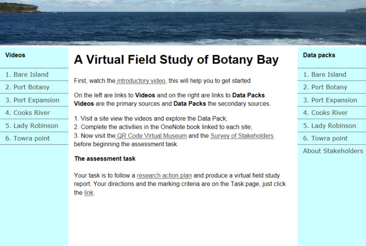
The left hand side gave students access to the videos while on the right were links to the Data Packs. The central area was a basic field study overview with the assessment task as the last link. It also included a link to a page entitled Survey of Botany Bay Stakeholders. This provided students with summaries of the survey findings.
Data Packs were organised with links to secondary sources organised according to:
- biophysical processes;
- human impacts; and,
- management strategies.
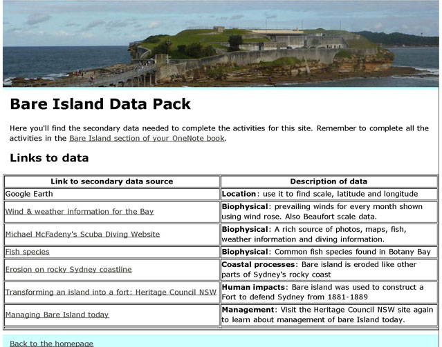
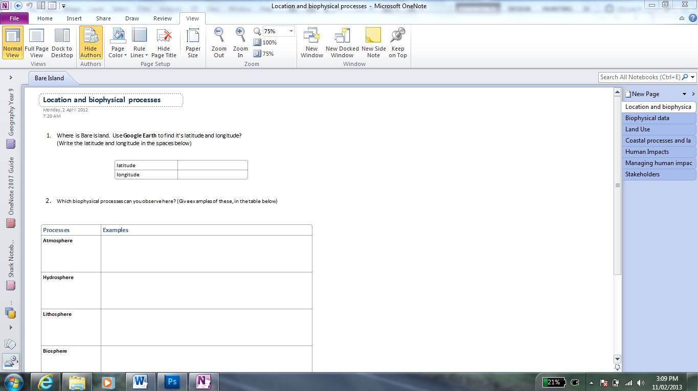
Each Data Pack was linked to its own section in a OneNote book that scaffolded students data collection and organisation helping them to shape their data towards the final assessment task by ensuring that it was organised into a form that addressed the basic research questions.
There is a downloadable PowerPoint that outlines the steps involved in building this field study. To download the display click Botany Bay Presentation

Leave a comment