One of the main reasons I’ve moved house was the absolute racket emanating from the building site next to my old place.
At first the disruption was modest preparation, over a month or so. It involved clearing a former parking lot, felling trees, building site huts, planning and constructing site drainage, installing generators, lighting and ground level sound barriers, Once complete cranes and boring equipment were moved on site and the slow task of sinking footing shafts begun.

The site was on what would have once been on a slip-off slope, a bend in the river. Although levelled and the river banks secured with stone walls, beneath the surface depositional layers remained much as they once were.
Close to the river the bores yielded alluvial deposits and then clay. On higher land and places further from the river it was thinner alluvial material, shale like dry clay and eventually a soft light gray rock. This was a moment of surprise an encounter with the familiar and the primal.
Tuff, or paras as it’s called in Indonesian, was a stone I’d often seen hewn from Balinese river valleys. There the grey rock is used in carving a pantheon of religious objects, decorative landscaping features and tourist souvenirs. To a geologically trained eye it is instantly recognisable as tuff, a volcanic sandstone. In Bali swift rivers have carved a radial system of ridges and valleys, deep into its layers. Yet now its sighting yielded memories beyond such geomorphic reflections.
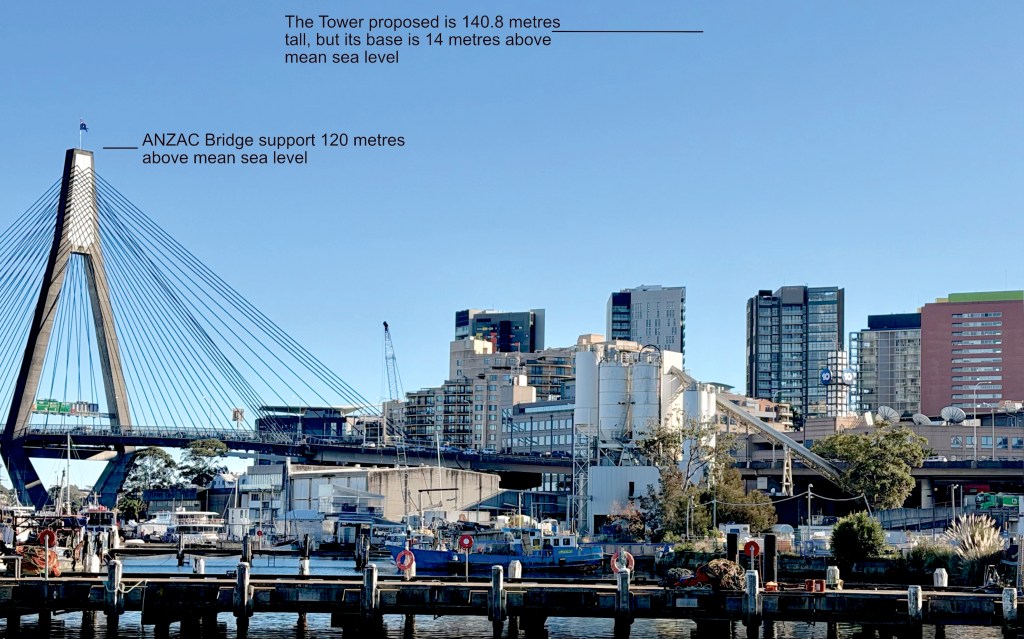
CIDH piles
Preparing the CIDH piles for a 36-story twin tower building required a lot of boring. Pile drillers equipped with soil augers were used first, as they bored deeper more robust rock augers were needed. As each load of debris was brought to the surface and the augur lifted from the hole its contents had to be spun off. This wasn’t a smooth rotation but a stop start action. At each jarring stop in the rotation the equipment generated a load percussive noise. With as many as three rigs going at once days were punctuated with this jarring cacophony. Retreating to the local mall was an easy option.
Tuff is a volcanic sandstone, consolidated ash fall. A soft rock that can sometimes be scored with a fingernail. There it was below, and Krakatau immediately came to mind.
Krakatau

Krakatau’s cataclysmic eruption, in August 1883 blew the cinder cone off its small island in the Sunda Straits. In rushing sea water induced a massive explosion of rocks and superheated steam. So loud was the explosion that stockmen driving cattle across Western Australia’s Hammersley Range thought it was artillery.
Reverberating from Bangkok to Manila, and from Saigon to Perth, tsunamis were recorded as far away as the West coast of the USA. In the now more connected world of the telegraph and undersea communications cables, reports of the eruption spread rapidly. Dutch authorities estimated the death toll 36,417 but with all such events, there can be no certain figure. Some suggest, more realistically, as many as 120,000 deaths.
Volcanic eruptions in historic times are well documented. Mt St Helens’ 1980 eruption in the Pacific Northwest is considered the most disastrous in US history. Extensively documented, it was a small geological event compared with Krakatua, yielding a mere 1.5 cubic km of tephra. In comparison Krakatua ejected 18 cubic km. Such catastrophic events have an impacts far beyond their immediate regions. Krakatau produced tsunamis that swept through the Sunda Straits. Yet none of these compared with the magnitude of the Tambora eruption.
Tambora
When Tambora erupted in 1815-16 it ejected 150 cubic km of tephra. At first its impact on a wider region was unnoticed but by the northern summer of 1816 Spanish records reveal a summer that never was. In Madrid, temperatures fell below 15ºC from July through to August. Rivers froze and peaks usually snow free bore white mantles. Tambora’s eruption was the largest in recorded history.
Mounds of tuff grew
Mounds of tuff grew beside the boring machines along with the realisation that these events were not likely responsible. One possibility remained shrouded in the uncertainties of prehistory.

Mount Toba
About 600 kilometres away on the island of Sumatra Mt Toba erupted in these prehistoric times. Somewhere about 75,000 ago it produced 1000 cubic km of tephra in the first nine days of its eruption, and over the course of this eruptive phase ejecting a total of from 2500-3000 km3.
Mapping the three volcanoes
Toba’s eruption
Toba’s eruption had planetary consequences triggering a volcanic winter, the Pleistocene Ice Age, and burying vast areas, along with their emerging megalithic cultures, under hundreds of metres of tephra. Sea levels fell as much as 150 metres and island hopping through the Indonesian archipelagos enabled human passage first east, and then south to Australia.

After the fall in sea level it was likely possible to walk from what is now Merauke to Darwin in about three weeks. The biophysical continuity is still is obvious, the ancient land connection documented in the cave art of Kakadu.
Toba today
Now the Toba caldera contains a huge lake. Visiting it some 20 years ago I captured these images.


My friend Wayan Cemul
This post is born of research for a short story I’ve just written about my friend I Wayan Cemul.

No longer with us, he was one of the best teachers and communicators I have ever met. Shortly I’ll post the audio version of the story, on this blog.
The following YouTube video was made while Cemul was still alive. I thank Hans and Fifi for this.


Leave a comment