Some would argue that the forests of Indonesia were undisturbed until recently but there can never be virgin rainforest once people are present. Beginning as far back
40,000 years ago a process of incremental transformation unfolded along the Indonesian archipelago. This was sustainable change all but invisible yet the very languages and cultures of the archipelago’s forest people were enmeshed and entwined in this process. For the most part, given the low population densities, it left closed canopy forest undisturbed, except for swidden[1] clearings.

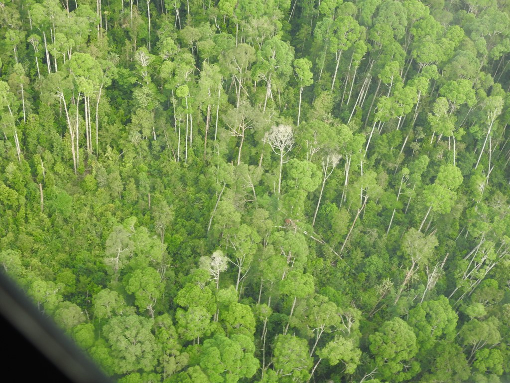
Almost 30 years ago, on an extended four-month journey through East Kalimantan and Sumatra, my expectation was an encounter with myriad plants and animals, of complex ecosystems optimising life forces and climaxing in total profusion. How wrong I was. Along East Kalimantan’s Mahakam river deforestation was extensive, rafts of logs floated down the great river, the primary rainforest was seldom seen, except on side trips along tributaries flowing through riparian swamp forest or peatlands.
The same was true in Sumatra except for the Bukit Barisan, reserves and national parks. Valuable timbers had been felled, first replaced by rubber plantations and then oil palms. Only in the Mentawai Islands did I begin to see what I had imagined, elsewhere exploitation of forest resources had already entered a new era though this space was also threatened.
Logging and plantation development, particularly on mineral soils was extensive. In Sumatra after valuable timbers were extracted, large areas were developed as rubber plantations which, after the development of synthetic rubber, were replaced by oil palm plantations. In both Kalimantan and Sumatra peatlands remained as refuges for a time, as places where complex ecosystems were still to be found.
The United Nations FAO reports Indonesia’s forest cover in 1990 as 1,185,450 sq kms, by 2010 this was reduced by 20.3% to 944,320 sq kms.[2]
Just last week I had a text message from my friend Ridwan who lives in Sungai Tohor, a district on the island of Tebingtinggi, in Riau Province. Tebingtinggi is part of the Meranti Island group lying on the western side of the Malacca Strait. His community is engaged in several projects aimed at restoring and establishing sustainable forms of farming. His story will form the next in a series of blog posts.
Riau Province location
Riau is bordered on the west by the Barisan Mountains. Its total area is 8,702,400 hectare.
Four major rivers, the Rokan, Siak, Kampar, and Indragiri Rivers flow into the Malacca Strait forming hill lands that rapidly expand into extensive peatlands.
Figure 2: Riau Province
Originally most of the vegetation cover started out as closed-canopy forest. About 40% of the province, around 3,400,000 hectares, is coastal peatland. The other 60% was equatorial forest established on mineral soils or, along the extreme coastal margins, nipa palm swamp and mangroves.
Riau’s mountain slopes still have forest cover while its hills and peatlands have been extensively cleared for plantations and farm land. The plantations involve oil palm cultivation and areas of industrial forests, where timber companies cultivate eucalypts, acacia and teak for timber and wood pulp. There is also some and farm land.
Riau’s peatland was laid down from the end of the Pleistocene Ice Age. On its seaward margins it forms the stabilised Holocene coastline. Here are Indonesia’s deepest peat deposits reaching over 10 meters depth and storing an estimated 16.4 gigatons of carbon, almost 25% of Indonesia’s total deposits. The province has been subjected to rapid and extensive deforestation. From 1990 its total forest area was reduced by 65 per cent and its peat forest cover from 80 per cent in 1990 to about 36 per cent in 2010.[3]
Changes in the management of forests
Until 1998 and the fall of Indonesia’s Suharto regime there was far more control of forests from the national level. Now through changes in law and regulation there has been a greater devolution in authority. Arnold notes in his article Deforestation in Decentralised Indonesia: What’s Law Got to Do with It?’ This was addressed in my earlier post Impacts of and responses to the dense smoke haze from #Indonesia.
With the passing of new regional autonomy and fiscal laws in 2004, regional governors and assemblies received a greater share of power. Regions are now able to exercise extensive autonomy over specific areas of governance, including forestry, provided that their decisions maintain social welfare, public service and regional competitiveness. At a provincial final authority rests with provincial government, districts/municipalities have jurisdiction over everything that is at that level alone. This leaves space for much ambiguity as provincial, regional and district boundaries rarely accord with discrete bio-geographic regions. Many trans-boundary issues arise.
To make matters more complex, provinces can ‘delegate’ authority to districts and/or municipalities, which can I turn delegate authority to villages. Authority over forestry can be so delegated.
Some indication of the land use and tenure of Riau province can be gleaned from this map in Figure 3. This map shows the proposed change in the forest area of Riau province based on the recommendations of an integrated team study. It forms the basis of a revised spatial plan for the province.


The map makes plans for further exploitation of Riaus forests abundantly clear. I will say more about this in subsequent posts.
Further detail on Riau land use can be observed in the transect map I have prepared.
Figure 4: A Riau Province transect
If you intend using any of the images linked to this map, please clarify the image content with me first and also acknowledge this blog on publication.
Fires of 2015
Devolution has ushered in a confusion of powers and responsibilities so it isn’t surprising that poorly regulated fire based land clearing techniques in Riau’s peatlands led to the catastrophic fires of 2015. This has also been covered in my earlier posts, particularly in Peatland and forest burning for palm oil production continues, but at what cost?
Legal and regulatory ambiguities afforded opportunities for poor decision making and corruption. The added problem of rural poor wanting a secure income source facilitated low yield unsustainable slash and burn agriculture.
Transforming closed-canopy forest into agriculture land
There is no absolute sequence of steps but there is a frequent pattern in the destruction of closed canopy forest.

Stage 1: Concession Selection Logging
Selective logging over a 20-year period. Logs are can be removed using push carts on portable light rail systems or slid along tree trunks. This opens of the canopy, as shown in Figure 6, lowering humidity and making forest prone to fires in dry periods. If selection cutting is carefully controlled such impacts can be contained but regulation is difficult.

Research conducted in the Mentawai Islands demonstrated the effect of logging just 8% of trees by selective logging led to destruction of 19% of the surrounding forest, 20% of forest was badly damaged with crowns and bark stripped, 7% of trees were seriously broken and 46% remained intact.[4]
Stage 2: More extensive illegal logging
When this takes place it can involve the use of small streams for log transport. Being non-selective this type of extraction can cause irreversible degrading of the forest ecosystem and loss of forest cover as shown in Figure 7.
Stage 3: Slash & Burn Encroachment
Drainage of peat is essential for any agricultural crop (except for sago on the coast). In some cases, small ditches left from previous illegal logging are used to assist peatland drainage. Once an area is dry fire is the cheapest means available for land clearing. On peatland, without rain, fires can smoulder and farmers are neither motivated nor do they have the capability to extinguish fires. When rains don’t come, as in the El Nino year of 2015 fires can spread, raging out of control.

Stage 4: Productive Agriculture
Next the opportunistic patchwork is gradually transformed into organized plantations of palm oil and rubber. Pioneers are bought or pushed out by larger organisations that have acquired concessional access or land titles. In these situations, the focus is on legal compliance but auditing is difficult and breaches of codes continue.

Stage 5: Integrated Land Use
A growing awareness of the unsustainable practices followed in Riau has led to a growing global demand for sustainable products. Haze free palm oil and sustainably produced paper products are in increasing demand. As a response, some palm oil and wood pulp plantation owners have attempted to adopt more sustainable practices and begun to set areas for conservation. In this way, they aim to demonstrate commitment to a business model that extends ‘beyond compliance’. Schemes such as the Round Table for Sustainable Palm Oil (RSPO) and the Forest Stewardship Council (FSC) for wood origin certification have begun to provide standards for assessing compliance with sustainable practices.
![]()
![]()
[1] Swidden agriculture is sometimes called shifting cultivation and also incorrectly confused with slash-and-burn farming. Swidden is an ancient form of land use that involves the clearing of land for cropping, followed by a period in which the land is left fallow. Swidden cultivators return to the cleared plots for another cycle of cropping after an interval in which soil fertility is able to regenerate as leaf and plant litter restore forest the humus layer.
[2] https://unstats.un.org/unsd/environment/forestarea.htm
[3] Thorburn, C. & Kull, C. – Peatlands and Plantations in Sumatra, Indonesia: Complex Realities for Resource Governance, Rural Development, and Climate Change Mitigation. Centre for Geography and Environmental Science Monash University, Melbourne, Australia. Pp. 5
[4] Whitten, T, Damanik, S J – Ecology of Sumatra. Periplus
[5] ibid
[6] Thorburn, C. – Managing peatlands in Indonesia: A case study of small islands in Riau Province, Sumatra. Monash University. MSI Report 13/19, October 2013. Pp 7
[7] ibid


Leave a comment