This morning I woke early. The usual dawn chorus of roosters was underscored by intense and sudden explosions of sound. Rice farmers were already at work clapping short lengths of bamboo, disturbing opportunistic flocks of birds settling for a morning feed in the sawah. It rained heavily the night before, a welcome event in an El Nino year. The air was saturated. Mist hung above the sawah. All of Gunung Agung’s 3142 metres, save for a cap of cloud, was stark and clear above the palms. Once staying in a similar location I became complacent about this early morning unveiling, then one afternoon it appeared from masses of convectional cumulus in a blaze of afternoon light. Now I’m more finely attuned to it’s shades and moods. Fortunately I’ve never been on the island when it’s erupted.
Contemporary Australians are most unaccustomed to volcanic events. There’s the occasional earthquake but, with the exception of the Newcastle earthquake, these are usually gentle shakes. Throughout much of the time mainland Australia (including Tasmania) has been inhabited, our volcanos haven’t been so benign. When I read Neil’s Blog on Australian volcanos, this morning, I was delighted that someone else has been enticed to comment on this little known aspect of Australia. Having said this, there’s often comment on the Heard Island strato volcano, Big Ben (2745 metres) which last erupted in 2001.
Some years ago I managed a team of writers and designed a book on the Geography of Australia, I even wrote one chapter myself. The book was ultimately published in Indonesia, on behalf of the Australia Indonesia Institute. It went by the unassuming name of Geografi Australia and it addressed the junior secondary Social Science curriculum in Indonesia. It also had a supplement to each chapter that addressed possible teacher interests. Since it was published in 1999, much of the Human Geography is now out of date, but the Physical Geography is still quite relevant.
An important element of the book was to expose and discuss geographic links between Australia and Indonesia. While at first there might seem to be few, the book addressed such links from cyanobacteria in our common waters to more complex geopolitical issues. Of course tectonically speaking, we are sliding slowly towards Indonesia at a rate of around 7cms a year. Ultimately the sediments on Australia’s continental shelf will form the magmas extruded from some of Indonesia’s volcanos. Of course that a long way of in the future, but it can still provoke an intriguing discussion amongst some of my more nationalistic Indonesian friends.
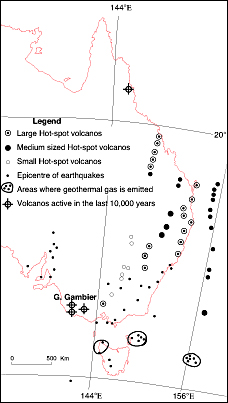
Back in Australia there are many signs of our ancient volcanos. In Geografi Australia one of the teacher supplements covered Australian volcanos. It had a map of Australian volcanos based on research from Dr Lin Sutherland Senior fellow in Geosciences at The Australian Museum. Below is an updated version of Dr Sutherland’s map.

For the observant traveller there are still many signs of the periods of vulcanism in Australia. Interestingly, unlike Big Ben, these were Hot-spot volcanos, similar to those found in the Hawaiian island chain. With such volcanos an intensely hot spot in the mantle occasionally burns through the overlying crust, causing flows of non-viscous to spreads out over vast areas. Such volcanos are associated with the explosive nature of strato volcanos like Mt Agung and Big Ben, any one who has watched the lava action on Kilauea will have a good sense of the nature of Australia’s ancient volcanos.
For the general observer the remains of Australia’s volcanos can be hard to detect. Certainly there are outstanding examples, like Queensland’s Glass House Mountains, or the Warrumbungles in NSW.
For me one of the most subtle, yet the most interesting volcanic landscapes in Australia, is the Monaro (pronounced mon-air-o). Here at least 630 cubic km of lava and pyroclasts were erupted during the 20 million-year long history, just 57.5 – 34.0 million years ago.
This is a shot of the Monaro after rain. It’s often in a rainsdow.

There’s a full sized version of this at Twitpics. For a more extensive photo treatment see Dr Ian Roach’s excellent photos.
It’s interesting to observe just how Australia’s slow northerly movement as a continent has resulted in the lines of former volcanos above the hotspots. I often wonder when things are going to heat up a little more in Bass Strait and north western Tasmania.
(A note on spelling – I can’t see any reason for using the spelling volcanoes.)


Leave a comment